

Who we are
HYDRO HUNTER deals with underground research, using fixed-wing and multi-rotor Remote Pilot Aircraft Systems, innovative in functionality and cutting-edge in terms of technology used, for applications in the professional field at the highest level.
for the research of: water through the identification of fresh and thermal aquifers , fractures , faults , landslides , archaeological finds , hidden treasures , illegal buried landfills and land with certain characteristics.
The project stems from the experiences of professionals active in the geophysical, computer and aeronautical sectors, who share a passion for technological development. Inside the production laboratory, sophisticated electronic components have been introduced for the production of sensors and electronic components for the specific drones themselves. We have succeeded in giving birth to the Poseidon system.
ELECTROMAGNETIC ANALYSIS OF THE SOIL – POSEIDON SYSTEM
The POSEIDON SYSTEM is a tool for geophysical research, to investigate in an “indirect” way in the subsoil, that is does not require excavations or drilling, therefore it is absolutely NOT INVASIVE . The POSEIDON SYSTEM could also be called “Hunter or Underground Researcher” as it is able to detect everything found underground, ie buried objects or natural materials.
In reality the POSEIDON SYSTEM does not detect objects but rather the Electromagnetic Anomalies (EM) produced by everything that has a different density and conductivity from what surrounds it; for example a boulder within a sandy soil, a mineralization within a rocky layer, a metal object, buried masonry, a landslide, but also a fracture or fault in the various layers that make up the subsoil. Over time our surveys are increasingly requested by professionals who need to carry out certain surveys on the territory such as: geologists, engineers, architects and archaeologists.
How does the POSEIDON SYSTEM work and what are the dimensions of the anomalies it can detect?
This depends on the size of the detection mesh, i.e. the distance between the various profiles. The profiles are straight lines that cross the area to be investigated with a parallel trend between them.
What depths can be reached with the Poseidon System?
The depth of investigation depends on many factors: size, nature of the object and type of soil are the most important, a metal mass of 30 cm can be detected up to an approximate depth of about 7/10 m while a series of fractures o a water basin (areas with lower density) up to 1000 ml can be detected in extremely favorable cases. Additional systems are being tested which will allow these limits to be overcome. But if the probe has to be carried by hand by the operator, how is it possible to investigate large extensions, for example for the purpose of large-scale water research? In this case a S.A.P.R. is used. (drone) radio-controlled with geo-referenced EM sensors on board, developed by our company, which, through a series of scheduled flights at low altitude, is able to detect anomalies on areas up to 100 hectares at a time, allowing them to subsequently investigate them in a targeted way, with the methods described above.
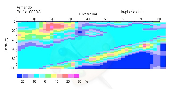
In this scheme it is easy to understand that in the color scale, the magenta colored ground is the hardest (rock type). The yellow color can be sand or clay and clearly the dark blue denotes the presence of water. The diagram very intuitively represents the horizontal metric scale, at a distance of 70 meters from our initial reference point with a depth of about 65 meters, we find the aquifer.
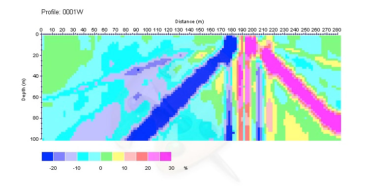
In this diagram we note the presence of a thermal spring, represented by the Dark Blue channel that reaches ground level. The vertical channels and the right oblique one of magenta color denote the channels of the sources closed by limestone.